
Date
08/01/2005
Journey there
| Dep. Garching-Hochbrück | 07:00 | (Meet on U-Bahn, via Marienplatz) |
| Arr. Hauptbahnhof | 07:29 | (Meet under departure board, platforms 25-26) |
| Dep. Hauptbahnhof | 07:42 | |
| Arr. Geitau | 08:54 |
Hike start point
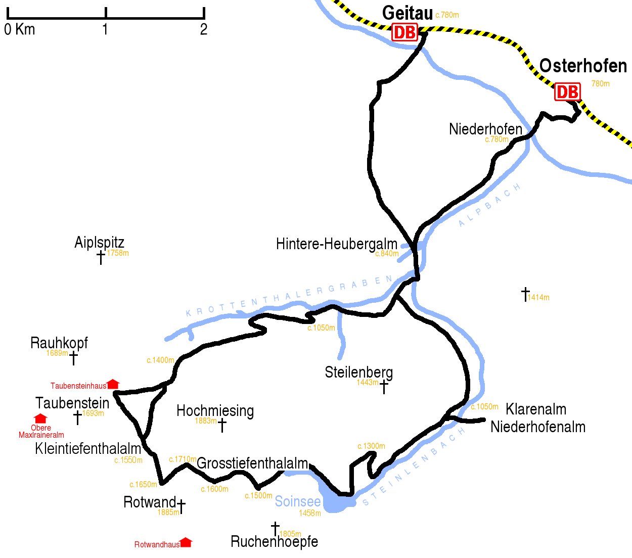
Hike map
Hike map in other formats
![]()
Hike description
- From Geitau Bahnhof (c.780m), walk east along the road next to the railway track and turn right at the junction.
- Walk 500m to the main road, cross it and continue south for another 500m.
- Follow the signs south in the direction of Seeberg and Rotwand for 2Km to Hintere Heubergalm (840m).
- There follow the signs to Rotwand and Miesing south for a couple of minutes and at the unsigned fork take the left fork.
- Proceed a further 500m and at the little bridge take the right turning towards Rotwand; do not continue on the turning to the left of the bridge as this leads to the southern end of the east side of the Steilenbach valley and, in the snow, it is impossible to find the path that – according to the map – crosses back onto the west side!
- 500m further on, take the left turning going clockwise round Steilenberg on the west side of the Steilenbach valley for 2Km until to where it is joined by the path from Klarenalm (c.1050m.).
- Continue west on the steep main path for 3Km to Soinsee (1458m).
- Follow the B4/645 west along the lake and for a further 1Km to the end of the large track (1500m).
- Then turn right, and go for 1Km up to the saddle between Rotwand and Hoch Miesing (c.1710m).
- Take the left path which goes south-west cutting across the back side of Rotwand for 500m before turning north-west and rapidly descending for 500m to Kleintiefenthalalm (c.1550m),
- Then go north-east for 1Km along the B7 to where it joins the B6.
- Then go north-east for 5Km along the B6 to the bridge over the Steilenbach (c.840m).
- After crossing the bridge, turn left and follow the sign for Geitau/Osterhofen/Bayrischzell for about 500m, going past the doubling-back unsigned left fork.
- Shortly after this doubling-back unsigned left fork, then take a right fork, which leads to Osterhofen, for 3Km.
- At the main road, turn right, and after 200m turn lef to Osterhofen Bahnhof (c.780m).
Hike end point
Afterwards
We’ll eat somewhere in Osterhofen (note that the Landgasthof Schäfer is permanently closed). (Please try to make it for the meal – it’s the best part of the day!)
Journey back
| Dep. Osterhofen | 16:10 | 17:10 | 18:10 | 19:10 | 20:10 | 21:10 | 22:10 |
| Arr. Hauptbahnhof | 17:29 | 18:29 | 19:29 | 20:29 | 21:29 | 22:29 | 23:29 |
Photos
See Grosstiefental.
Important stuff
- If you want to share a group ticket let me know!
- You should definitely check the weather!
- For my peace of mind, some conditions apply!